Sudbury's one shopping area is along Route 20, near Union Street. Here, Route 20 is a commercial strip with relatively wide lanes, traffic signals and many crossing and turning movements.
In the southeast corner of town, south of Route 20, there is some residential development. One interesting detail: a path cutting through the woods from residential streets to the Congregation Brith Torah on Woodside Street.
The south central section of town is undevelopable, a large swampy area used for the town's wellfield. Development and traffic are light in the southwest corner and along the east edge of town, bounded by the Sudbury River. The military reservation along the western boundary is another barrier which diverts through traffic.
In all of the rest of Sudbury, the story is the same: residential infill development along narrow, hilly, winding old farm roads. To its credit, Sudbury has built sidewalks along most of these roads, and the sidewalks are used by novice and child bicyclists: but they are not suitable for travel at normal bicycle speeds.
The quality of the farm roads themselves for bicycle travel depends on their location and the resulting traffic volume. This volume is not high, even near the center of town, but it is still enough to intimidate less-experienced adult bicyclists on many of these streets in rush hour. A program of bicyclist and motorist education and speed limit enforcement would help; but with continuing development, the problem can be expected to worsen somewhat. Widening these streets would pose serious political problems due to their being bounded by sidewalks and residences, and due to the loss of their rural character which is one of the appeals of Sudbury in spite of its increasing suburbanization.
Of the major arterials through town, only Route 20 has wide lanes or shoulders, and only in the shopping district and for a mile or so at the west end of town. Union Street/Concord Road/Pantry Road; Route 27; Hudson Road; and Route 117 all are 24 feet wide without shoulders for most of their length in Sudbury. These arterials can and should be given two additional feet of shoulder during the course of normal repair and upgrading. A first candidate for this treatment is Hudson Road, whose pavement is in bad condition at this time.
Three other initiatives would go a long way to improve bicycling conditions in Sudbury:
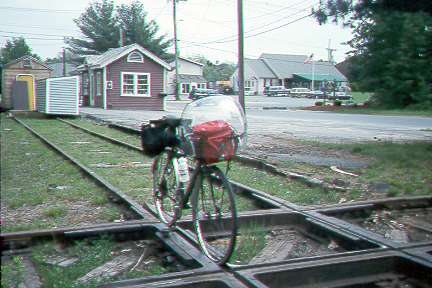
1) Development of the abandoned east-west and north-south rail axes which crisscross the town as bicycle paths. Ownership of the east-west path is with the MBTA, as described in the Hudson report; the north-south section is abandoned and has already been proposed as a bicycle path, though it met some opposition in communities farther north. The path could, and should, be improved in Sudbury for local access, regardless of plans in the other communites.
Paths in Sudbury should attract very heavy local traffic comparable to that on the Minuteman path, due to the population density of Sudbury and the absence of other attractive route options. The expense of about $1,000,000 for approximately ten miles of path would be justified in terms of use. The two rail lines converge conveniently on the town's shopping district, with the east-west line potentiallys providing access to additional shopping and employment centers to the east along Route 20.
Crossing of the two abandoned rail lines in the center of Sudbury
2) "Cut-through" paths should link the back ends of residential subdivisions with each other and with local destinations such as playing fields, schools and houses of worship. There are many opportunities for such paths in Sudbury, probably others besides those indicated on the map, and as noted, one already exists in the southeast corner of town.
3) Another shopping district is needed at the north end of town to reduce the excessive trip distances to obtain even the smallest necessities.